Tropical Cyclones
Formation, Classification and Naming
A tropical cyclone is a huge, spinning storm that forms over warm tropical seas. At its centre is an area of very low air pressure. Winds rush in towards this centre, spiral upward and bring very strong winds, heavy rain and a rise in sea level near the coast. In India, the east coast faces the most cyclones, especially Odisha, Andhra Pradesh, Tamil Nadu and West Bengal.
Why do cyclones matter so much for India?
India's coastline is about 11,099 km long (the official figure after a re-measurement with modern maps; the older figure was 7,516.6 km), and millions of people live in low-lying coastal districts. A single strong cyclone can destroy homes, crops, roads and power lines, and push seawater far inland. The 1999 Odisha super cyclone killed about 10,000 people.
Since then, India has greatly improved warnings and evacuation, so deaths have fallen sharply. But damage to property and livelihoods is still very high. That is why understanding cyclones is part of both geography and disaster management.
How does a cyclone form?
Think of the warm sea as a giant stove and the cyclone as a heat engine that runs on it. The steps are:
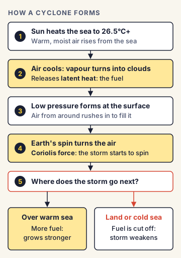
- The sun heats the sea surface. Warm, moist air rises from the sea.
- As this air rises, it cools, and the water vapour turns into clouds and rain. This releases heat, called latent heat, into the air. This heat is the cyclone's fuel.
- The rising air leaves behind lower pressure near the sea surface. Air from around rushes in to fill the gap.
- Because the Earth spins, the incoming air does not move straight in. It gets turned, and starts to spin around the centre. This turning effect is called the Coriolis force.
- As long as the storm stays over warm water, it keeps getting more fuel and grows stronger. When it moves over land or cold water, its fuel is cut off and it weakens.
What conditions are needed?
A cyclone forms only when several conditions come together:
- Warm sea water: The sea surface temperature should be at least about 26.5°C, and this warm layer should go down to a depth of around 50 metres.
- Coriolis force: It must be strong enough to start the spin. It is almost zero at the equator, so cyclones rarely form within about 5° of latitude of the equator.
- Low vertical wind shear: Winds at the bottom and top of the atmosphere should not differ much in speed or direction. Strong shear tears the storm apart before it can grow.
- A starting disturbance: An existing area of low pressure or weak circulation.
- Moist air in the middle levels of the atmosphere, and air flowing outward at the top (upper-level divergence), which acts like a chimney pulling air up.
The structure of a cyclone
- Eye: The calm centre, usually 20 to 50 km wide, with light winds, clear skies and the lowest pressure.
- Eyewall: A ring of tall clouds right around the eye. It has the strongest winds and heaviest rain.
- Rain bands: Spiral bands of cloud and rain that stretch outward for hundreds of kilometres.
In the Northern Hemisphere, cyclone winds spin anticlockwise. In the Southern Hemisphere, they spin clockwise. This is because of the direction of the Coriolis force in each half of the globe.
What causes the damage?
A cyclone harms people in three main ways:
- Strong winds that flatten houses, trees and power poles.
- Heavy rain that causes floods and landslides.
- Storm surge: an abnormal rise in sea level, pushed by the winds towards the coast. This is usually the deadliest part. The shallow, funnel-shaped coasts of the Bay of Bengal make storm surges higher there.
How does IMD classify them?
The IMD classifies storms over the North Indian Ocean by their maximum sustained wind speed (averaged over 3 minutes):
| Category | Wind speed (knots) | Wind speed (kmph) |
|---|---|---|
| Low pressure area | below 17 | below 31 |
| Depression | 17 to 27 | 31 to 49 |
| Deep depression | 28 to 33 | 50 to 61 |
| Cyclonic storm | 34 to 47 | 62 to 88 |
| Severe cyclonic storm | 48 to 63 | 89 to 117 |
| Very severe cyclonic storm | 64 to 89 | 118 to 166 |
| Extremely severe cyclonic storm | 90 to 119 | 167 to 221 |
| Super cyclonic storm | 120 and above | 222 and above |
A storm gets a name only when it reaches the cyclonic storm stage (34 knots, or 62 kmph).
How are cyclones named?
Naming makes it easier for people, the media and governments to talk about a storm and avoid confusion when two storms exist at the same time.
- For the North Indian Ocean (the Bay of Bengal and the Arabian Sea), names are given by the Regional Specialised Meteorological Centre (RSMC), New Delhi, run by the IMD.
- The names come from a list agreed by the WMO/ESCAP Panel on Tropical Cyclones. WMO is the World Meteorological Organization; ESCAP is the UN Economic and Social Commission for Asia and the Pacific.
- Naming in this region began in 2004. The first list ended with Cyclone Amphan in 2020.
- A new list of 169 names was released in April 2020: 13 names each from 13 member countries (Bangladesh, India, Iran, Maldives, Myanmar, Oman, Pakistan, Qatar, Saudi Arabia, Sri Lanka, Thailand, UAE and Yemen).
- Names are used one after another, column by column, and a name is never reused in this region.
- Names must be short, easy to say, and must not hurt the feelings of any group. For example, "Arnab" was given by Bangladesh and "Murasu" (a traditional Tamil drum) by India.
Where and when do Indian cyclones form?
Most form in the Bay of Bengal. Over the long term, about four cyclones form in the Bay of Bengal for every one in the Arabian Sea. The Bay is warmer, gets more moisture from big rivers, and also receives leftover storms that travel west from the Pacific. Recent studies show the Arabian Sea is becoming more active as it warms.
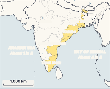
There are two cyclone seasons: pre-monsoon (April to June) and, the busier one, post-monsoon (October to December). Cyclones are rare in the peak monsoon months because strong wind shear stops them from growing.
India's warning system
The IMD gives cyclone warnings in four stages before a storm hits the coast:
- Pre-cyclone watch: issued about 72 hours before bad weather is expected.
- Cyclone alert: at least 48 hours in advance.
- Cyclone warning: at least 24 hours in advance; the expected landfall point is given at this stage.
- Post-landfall outlook: at least 12 hours before landfall, telling inland areas what to expect after the storm crosses the coast.
Better satellites, Doppler weather radars along the coast and computer weather models have made these forecasts much more accurate in the last two decades.
Commonly confused concepts
- Cyclone vs hurricane vs typhoon: These are the same kind of storm with different local names. It is called a cyclone in the Indian Ocean, a hurricane in the Atlantic and eastern Pacific, and a typhoon in the western Pacific.
- Tropical cyclone vs temperate (extra-tropical) cyclone: A tropical cyclone forms over warm seas between the tropics and gets its energy from latent heat. A temperate cyclone forms in middle latitudes where warm and cold air masses meet (along a front). It covers a larger area but usually has weaker winds. The Western Disturbances that bring winter rain to north India are temperate systems.
- Storm surge vs tsunami: A storm surge is caused by wind and low pressure during a cyclone. A tsunami is caused by an undersea earthquake, landslide or volcano, and can come without any storm.
- Landfall vs crossing the coast: Landfall is when the centre (eye) of the cyclone reaches the coast. Strong winds and rain can start many hours before landfall.
- IMD scale vs Saffir-Simpson scale: The IMD scale (3-minute average winds) is used for the North Indian Ocean. The Saffir-Simpson scale (Category 1 to 5, using 1-minute average winds) is used for Atlantic hurricanes.
Issues, criticism and the way forward
- A warming ocean: Warmer seas can make cyclones intensify faster (rapid intensification), leaving less time for preparation. The rise in Arabian Sea cyclones is linked to warming.
- Damage still high: Warnings save lives, but crops, fishing boats, homes and power networks still suffer huge losses, as in this news. Building strength into infrastructure is now as important as evacuation.
- Coastal ecosystems: Mangroves and coastal forests reduce the force of storm surges. Their loss to farming and construction makes coasts more exposed.
- Last-mile reach: Fishers at sea, migrant workers and people without phones may miss warnings.
- Way forward: Experts suggest underground power cables in cyclone-prone towns, more multipurpose cyclone shelters, stronger housing codes, mangrove restoration, impact-based forecasting (telling people what the storm will do, not just how strong it is), and crop insurance that pays out quickly.
Concepts to Know
- Low pressure: An area where the air presses down less on the surface than in nearby areas. Air always moves from high pressure towards low pressure.
- Latent heat: Heat released when water vapour turns back into liquid water. It warms the air and powers the cyclone.
- Coriolis force: An apparent force caused by the Earth's rotation, which turns moving air to the right in the Northern Hemisphere and to the left in the Southern Hemisphere.
- Knot: A unit of speed used at sea and in weather. One knot is about 1.85 kmph.
- Wind shear: A change in wind speed or direction with height.
- Doppler weather radar: A radar that tracks rain and wind inside a storm, helping forecasters see a cyclone's strength and path as it nears the coast.
- Minimum sea surface temperature for formation: about 26.5°C (warm layer about 50 m deep)
- Cyclones rarely form within about 5° of the equator (weak Coriolis force)
- Spin: anticlockwise in the Northern Hemisphere, clockwise in the Southern Hemisphere
- IMD naming threshold: cyclonic storm, 34 knots (62 kmph)
- Super cyclonic storm: 120 knots (222 kmph) or more
- Naming in the North Indian Ocean since 2004; new list of 169 names (13 countries × 13 names) released April 2020; names are not reused
- RSMC New Delhi (IMD) names North Indian Ocean cyclones
- Bay of Bengal to Arabian Sea cyclone ratio: about 4:1 over the long term
- Seasons: pre-monsoon (April to June) and post-monsoon (October to December)
- IMD four-stage warning: pre-cyclone watch (72 hours), cyclone alert (48 hours), cyclone warning (24 hours), post-landfall outlook (12 hours)
● Tracked since November 07, 2026 · last seen November 07, 2026 · updates as the daily brief publishes