South China Sea Dispute and the Nine-Dash Line
The South China Sea is a large, busy sea in Southeast Asia, bordered by China, Taiwan, Vietnam, the Philippines, Malaysia, Brunei and Indonesia. Several of these countries claim the same islands, reefs and waters, and they disagree about who owns them. China makes the largest claim, using a U-shaped line on its maps called the nine-dash line, which covers most of the sea.
In 2016, an international tribunal ruled that China's claim to "historic rights" inside this line has no legal basis under the law of the sea. China rejects that ruling, and the dispute remains one of the main flashpoints in Asia.
Why does this sea matter so much?
Think of the South China Sea as a busy highway that connects the Indian Ocean to the Pacific. A very large share of world trade passes through it every year, including oil and gas going to China, Japan and South Korea. One estimate puts the trade passing through at about US$3.37 trillion a year, roughly a third of global sea trade.
The sea also has rich fishing grounds and is believed to hold oil and natural gas under the seabed. Whoever controls its islands can also control a large area of sea around them. That is why small rocks and reefs have become so important.
Who claims what?
There are two main groups of islands, plus some important single features.
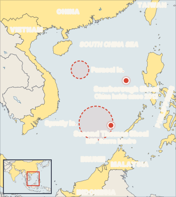
- Paracel Islands: in the north-west. Claimed by China, Taiwan and Vietnam. China has controlled them since 1974, when it took them by force from South Vietnam.
- Spratly Islands: in the south. Claimed fully by China, Taiwan and Vietnam, and partly by the Philippines, Malaysia and Brunei. Different countries occupy different features here.
- Scarborough Shoal: a ring of reefs west of the Philippine island of Luzon. Claimed by China, Taiwan and the Philippines. China has controlled access to it since a standoff in 2012.
- Second Thomas Shoal: in the Spratlys, inside the Philippines' Exclusive Economic Zone. In 1999 the Philippines deliberately ran an old navy ship, the BRP Sierra Madre, aground there. A small group of Filipino marines still lives on the rusting ship. Chinese coast guard ships often try to block the Philippines from sending food and supplies to them.
Where did the nine-dash line come from?
In December 1947, the Republic of China (the government that later moved to Taiwan) published a map with an eleven-dash line around the South China Sea. After the Communist Party set up the People's Republic of China in 1949, China kept the line. In the early 1950s it removed two dashes in the Gulf of Tonkin, near Vietnam, so it became the nine-dash line.
China has never clearly explained what the line means: whether it claims only the islands inside it, or the waters too. In August 2023, China's "standard map" added a tenth dash east of Taiwan. The Philippines, Malaysia and others rejected that map. India also protested, because the same map showed Arunachal Pradesh and Aksai Chin as Chinese territory.
What does the law of the sea say?
The main rulebook is the United Nations Convention on the Law of the Sea (UNCLOS), adopted in 1982. It lets a coastal country claim sea zones measured from its coast:
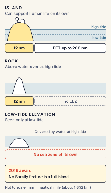
- Territorial sea: up to 12 nautical miles. The country has full control here, like its own land, but foreign ships may pass peacefully.
- Exclusive Economic Zone (EEZ): up to 200 nautical miles. The country alone may fish and take oil, gas and minerals here, but other countries' ships and planes can still move freely.
- The type of feature matters. A true island (one that can support human life on its own) gets a territorial sea and an EEZ. A rock that stays above water at high tide gets only a 12-nautical-mile territorial sea. A low-tide elevation (visible only at low tide) gets no sea zone of its own.
This is why the shape and type of each reef is fought over. If a feature counts as an "island", its owner gains a huge EEZ.
The 2016 arbitration (Philippines v. China)
After the 2012 Scarborough Shoal standoff, the Philippines started a case against China on 22 January 2013. It used Annex VII of UNCLOS, which allows a country to take a dispute to an arbitral tribunal (a panel of judges chosen for one case). The Permanent Court of Arbitration in The Hague handled the paperwork. The Philippines did not ask who owns the islands, because UNCLOS cannot decide ownership of land.
It asked only about sea rights. China refused to take part. On 12 July 2016, the five-member tribunal ruled unanimously:
- China's claim to historic rights to resources inside the nine-dash line has no legal basis, where it goes beyond what UNCLOS allows. Any such rights ended when China joined UNCLOS.
- None of the Spratly features is a full "island" able to create an EEZ. Some are only rocks; some are low-tide elevations.
- Second Thomas Shoal and Mischief Reef are low-tide elevations inside the Philippines' EEZ.
- China broke the Philippines' rights by blocking Filipino fishing and oil work, and its large-scale island-building caused severe harm to coral reefs.
China called the award "null and void". Under UNCLOS the award is binding on both parties, but there is no world police to enforce it.
How are the countries trying to manage the dispute?
In November 2002, ASEAN and China signed the Declaration on the Conduct of Parties in the South China Sea (DOC) in Phnom Penh. It is a political promise, not a binding treaty: the parties agreed to settle disputes peacefully and avoid steps that make tensions worse, such as settling people on empty features. Since then, ASEAN and China have been negotiating a fuller, more detailed Code of Conduct (COC).
In July 2023 they agreed to try to finish it within three years. The Philippines, as ASEAN chair in 2026, has pushed to conclude it this year, but differences remain on whether it will be legally binding and what area it will cover.
India's position and interests
India is not a claimant, but it has big interests. A large share of India's trade with East Asia (China, Japan, South Korea and the ASEAN countries) passes through these waters, and Indian state company ONGC Videsh has worked on oil blocks off Vietnam. India's position rests on four points: freedom of navigation and overflight, peaceful settlement of disputes, respect for international law, especially UNCLOS, and support for an effective Code of Conduct that does not hurt the rights of non-parties like India.
In a joint statement with the Philippines in June 2023, India for the first time openly called for adherence to the 2016 Arbitral Award. India and the Philippines signed a deal for BrahMos supersonic cruise missiles worth US$375 million in 2022 (deliveries began in April 2024), and the two countries raised their ties to a Strategic Partnership in August 2025.
Commonly confused concepts
- Nine-dash line vs EEZ: The EEZ is a zone that UNCLOS gives every coastal country, measured 200 nautical miles from its coast. The nine-dash line is China's own map line, drawn in the 1940s, and it is not measured from any coast.
- Arbitration vs International Court of Justice (ICJ): The 2016 case was not decided by the ICJ. It was decided by an arbitral tribunal under Annex VII of UNCLOS, with the Permanent Court of Arbitration acting as its registry. The Permanent Court of Arbitration is not a UN court.
- DOC vs COC: The DOC (2002) already exists but is non-binding and broad. The COC is the detailed code still under negotiation.
- South China Sea vs East China Sea: The East China Sea dispute is mainly between China and Japan over the Senkaku Islands (called Diaoyu by China). The Philippines and Vietnam are not part of it.
- Island vs rock vs low-tide elevation: Only a true island gets an EEZ; a rock gets just 12 nautical miles; a low-tide elevation gets nothing of its own.
Issues, criticism and the way forward
- Militarisation: China has turned several reefs into artificial islands with runways, ports and radar. Other claimants have also built on features they hold, though on a much smaller scale.
- Grey-zone tactics: Much of the pressure comes from coast guard ships and "maritime militia" fishing boats using water cannons and blocking moves. These actions stay below the level of open war, so they are hard to answer.
- Enforcement gap: The 2016 award is legally binding, but China ignores it. This shows the limits of international law when a strong power refuses to accept a ruling.
- ASEAN divisions: ASEAN works by consensus (everyone must agree). Some members have close economic ties with China and avoid strong statements, which slows the Code of Conduct.
- Way forward suggested by experts: a binding, effective Code of Conduct consistent with UNCLOS; hotlines and rules for unplanned encounters at sea; joint fishing and resource arrangements; and support from outside partners (including India, Japan and the Quad) for maritime awareness and coast guard training, without turning the region into a battleground of rival blocs.
Concepts to Know
- Nautical mile: A unit used at sea. One nautical mile is about 1.852 km, so 200 nautical miles is about 370 km.
- Sovereignty: Full ownership and control of a territory by a country.
- Arbitral tribunal: A small panel of judges chosen for one particular case, instead of a permanent court.
- Freedom of navigation: The right of ships of every country to sail through international waters and through other countries' EEZs without asking permission.
- Grey-zone tactics: Pressure that is stronger than normal diplomacy but stops short of open war, such as blocking boats or using water cannons.
- Artificial island: A reef that has been built up with sand and concrete dredged from the seabed so that buildings and runways can be put on it.
- Claimants: China, Taiwan, Vietnam, the Philippines, Malaysia, Brunei (Indonesia disputes China's line near its Natuna Islands)
- Eleven-dash line map: December 1947 (Republic of China); became the nine-dash line in the early 1950s; tenth dash added on China's 2023 standard map (28 August 2023)
- Paracels under Chinese control since 1974; Scarborough Shoal standoff in 2012; BRP Sierra Madre grounded on Second Thomas Shoal in 1999
- UNCLOS adopted in 1982: territorial sea 12 nm, EEZ 200 nm
- Philippines v. China: filed 22 January 2013 under UNCLOS Annex VII; award on 12 July 2016; five judges, unanimous; China called it "null and void"
- DOC signed in Phnom Penh in November 2002; COC still under negotiation (ASEAN and China aimed in 2023 to finish within three years)
- India first called for adherence to the 2016 award in a joint statement with the Philippines (June 2023); India-Philippines BrahMos deal worth US$375 million (2022); Strategic Partnership (August 2025)
● Tracked since August 08, 2026 · last seen November 17, 2026 · updates as the daily brief publishes