India-China Transboundary River Cooperation
The Brahmaputra Data-Sharing Mechanism
India and China share several big rivers that start in Tibet and flow down into India. The most important are the Brahmaputra (Yarlung Tsangpo) and the Sutlej (Langqen Zangbo). India and China have no water-sharing treaty for these rivers. Instead, they cooperate through a few simple arrangements: agreements (MoUs) under which China shares river data during the flood season, and an Expert Level Mechanism (ELM) where officials from both sides meet to discuss river issues.
Why does this cooperation matter?
China is the upper riparian country, meaning the river passes through China first. India (and then Bangladesh) is downstream. Whatever happens upstream, such as heavy rain, a landslide blocking the river, or water released from a dam, reaches India later. If India knows the water level and rainfall in Tibet early, it can warn people in Arunachal Pradesh and Assam before a flood arrives. Think of it like a phone call from a neighbour living uphill, saying "a lot of water is coming your way".
How big is China's share of the river?
By one widely used estimate, about 50.5% of the Brahmaputra basin lies in China (Tibet), 33.6% in India, 8.1% in Bangladesh and 7.8% in Bhutan. The river is about 2,880 km long by this estimate, with about 1,625 km in Tibet, 918 km in India and 337 km in Bangladesh. Different sources give somewhat different figures.
Much of the water in the Brahmaputra in India comes from heavy monsoon rain and tributaries inside India, but the flow from Tibet still matters a lot, especially in the dry season and in sudden floods.
How did the cooperation start?
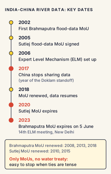
- 2002: India and China signed the first MoU (Memorandum of Understanding) under which China agreed to give India flood-season data on the Brahmaputra. It was renewed in 2008, 2013 and 2018.
- 2005: A similar MoU was signed for the Sutlej. It was renewed in 2010 and 2015.
- 2006: The two countries agreed to set up the Expert Level Mechanism (ELM) on trans-border rivers. Technical experts from the water ministries of both countries meet in it, usually once a year, taking turns to host. The 14th meeting was held in New Delhi in June 2023.
- 2013: A further MoU on strengthening cooperation on trans-border rivers was signed.
How does the data-sharing work?
Under the 2018 MoU on the Brahmaputra:
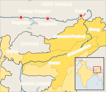
- China gives India data on water level, discharge (amount of water flowing) and rainfall.
- The data comes from three stations in Tibet: Nugesha, Yangcun and Nuxia.
- It is shared during the flood season, from 15 May to 15 October each year, usually twice a day.
- China also agreed to share data outside the flood season if the water level crosses an agreed limit.
- India pays China for this data. Indian Central Water Commission flood forecasters use it to warn people in the Northeast.
When has data-sharing stopped?
- In 2017, China did not share data, saying its measuring stations were being upgraded. This was the same period as the Doklam standoff between India and China. Data-sharing resumed in 2018.
- The Sutlej MoU expired in 2020 and the Brahmaputra MoU expired on 5 June 2023. According to the Indian government, data on the Brahmaputra stopped from June 2023, and Sutlej data had not been received since 2022.
- In 2025 and 2026, India repeatedly raised the need to resume data-sharing and to hold the next ELM meeting. As of May 2026, India was still pressing for an early ELM meeting. Whether the MoUs have been formally renewed is not confirmed [Unverified].
What does international law say?
There is a global treaty on shared rivers: the UN Convention on the Law of the Non-Navigational Uses of International Watercourses, adopted by the UN General Assembly on 21 May 1997. It came into force on 17 August 2014. It asks countries to use shared rivers in a "reasonable and equitable" way and not to cause "significant harm" to other countries. China voted against it (along with Turkey and Burundi), and India abstained. Neither country is a party, so it does not bind them.
India's position
India's stated position is that, as a downstream country, it has a legitimate interest in the Brahmaputra. India has asked China to make sure that upstream projects do not harm downstream areas, to be transparent about them and to consult downstream countries. India has also said it is monitoring China's projects and taking steps to protect its own interests, including building its own infrastructure such as the Siang Upper Multipurpose Project.
Commonly confused concepts
- MoU vs treaty: An MoU is a written understanding, usually not legally binding, and easy to stop or not renew. A treaty is a legally binding agreement. India and China have only MoUs on rivers, no water treaty.
- India-China arrangement vs Indus Waters Treaty: India and Pakistan have a full water-sharing treaty (the Indus Waters Treaty, 1960, made with World Bank help), which divides the rivers between the two countries. India and China have nothing like it; they only share flood data.
- India-Bangladesh Ganga Treaty (1996): India has a water-sharing treaty with Bangladesh for the Ganga at Farakka, signed in 1996 for 30 years. Do not mix it up with the Brahmaputra arrangements.
- Upper riparian vs lower riparian: The upper riparian country is the one where the river flows first (China for the Brahmaputra). The lower riparian is the one downstream (India, then Bangladesh). Note that India is lower riparian to China but upper riparian to Bangladesh.
Issues, criticism and the way forward
- Too narrow: The arrangement covers only flood-season data, not water sharing, dam plans or sediment. Experts point out that hazards outside the flood season, such as landslide dams, are not fully covered.
- Fragile: Since these are MoUs, data-sharing has stopped whenever relations have been tense. Some experts say China prefers MoUs because they are easier to suspend.
- Mega dams upstream: China's 60 GW Medog project has made data and transparency even more important for India.
- Way forward: Experts suggest year-round data-sharing, more stations, sharing of dam operation plans, an early-warning system for disasters, regular ELM meetings and, in the long run, a more formal water dialogue that also includes Bangladesh.
Concepts to Know
- Transboundary (trans-border) river: A river that flows through more than one country.
- Riparian: Related to the banks of a river. A "riparian country" is a country through which the river flows.
- Hydrological data: Information about water in a river, such as its level, how much water is flowing and how much rain has fallen in the area.
- Discharge: The amount of water flowing past a point in a river in a given time, usually measured in cubic metres per second.
- Central Water Commission (CWC): India's main technical body for water resources, under the Ministry of Jal Shakti. It issues flood forecasts.
- No India-China water-sharing treaty exists; cooperation is through MoUs and the ELM
- Brahmaputra data MoU: first in 2002; renewed 2008, 2013, 2018; expired 5 June 2023
- Sutlej data MoU: 2005; renewed 2010, 2015; expired 2020
- Expert Level Mechanism set up in 2006; 14th meeting in New Delhi, June 2023
- Data stations in Tibet: Nugesha, Yangcun, Nuxia; flood season 15 May to 15 October
- Brahmaputra basin shares (one estimate): China 50.5%, India 33.6%, Bangladesh 8.1%, Bhutan 7.8%
- UN Watercourses Convention: adopted 21 May 1997, in force 17 August 2014; China voted against, India abstained
● Tracked since October 08, 2026 · last seen October 08, 2026 · updates as the daily brief publishes