Seasonal Snow Cover and Snowmelt
How Mountain Snow Feeds Rivers
Updated 19 Nov 2026: Added how Ladakh stores winter water for spring: Chewang Norphel's artificial glaciers (1987) and Sonam Wangchuk's ice stupas (2013 to 2014).
Every winter, snow falls on high mountains and covers the ground like a white blanket. This is called seasonal snow cover, because it builds up in winter and melts in spring and summer. When it melts, the water flows into streams and rivers. So winter snow works like a natural water tank: it stores winter's rain and snow and releases it slowly in the dry months, when people and crops need water most.
Why does it matter?
In many mountain regions, rain does not fall evenly through the year. Winter snow fills the gap. In the Himalaya, snowmelt keeps rivers flowing in March, April, May and early June, before the monsoon rains arrive. This is exactly the time when the rabi crop is ripening, summer heat is rising, and cities and hydropower dams need steady water. If the snow is thin or melts too early, rivers can run low just when demand is highest. Scientists call such a year a "snow drought".
How is snow different from glaciers and permafrost?
Students often mix these up, so learn the differences:
- Seasonal snow: Fresh snow that lasts only a few months and melts every year. It is renewed every winter.
- Glacier: A huge, slow-moving body of ice made from snow that has piled up and pressed down over many years, even centuries. Glaciers do not vanish every summer. They lose some ice in summer and gain some in winter.
- Permafrost: Ground (soil or rock) that stays frozen for at least two years in a row.
All three are parts of the cryosphere, the frozen part of the Earth.
Where does the snow in the Himalaya come from?
The Himalaya gets snow from two main sources:
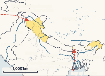
- Western disturbances in winter (December to March). These are storm systems that come from the Mediterranean region and bring most of the winter snow to the western Himalaya: Jammu and Kashmir, Ladakh, Himachal Pradesh and Uttarakhand.
- The south-west monsoon in summer. This brings heavy rain, and snow at very high altitude, mainly to the central and eastern Himalaya (Nepal, Sikkim, Bhutan, Arunachal Pradesh).
So the western basins like the Indus depend much more on winter snow, while the eastern basins like the Brahmaputra depend more on monsoon rain.
How do scientists measure snow?
Scientists use several measures. The main ones are:
- Snow cover (snow cover area): How much land is under snow at a given time.
- Snow persistence: The share of time that snow stays on the ground during the snow season, worked out for every small patch of land. For example, if a patch has snow on 60 out of 100 days, its snow persistence is 60%. High persistence means the snow stayed for a long time; low persistence means it melted fast or never settled.
- Snow water equivalent (SWE): How much water you would get if you melted all the snow. A thick, wet snow layer has more water than a thin, fluffy one.
ICIMOD measures snow persistence across the Hindu Kush Himalaya using images from MODIS, a sensor on NASA's Terra and Aqua satellites. Its records start in 2003. It compares each year with the long-term average to say whether the year is "above normal" or "below normal". This difference from average is called an anomaly. For example, "−20% anomaly" means 20% less snow persistence than normal.
How much river water comes from snowmelt?
ICIMOD estimates that snowmelt gives about 23% of the total water in the 12 major river basins that start in the HKH. The share varies a lot by basin:
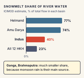
- Helmand: about 77%
- Amu Darya: about 74%
- Indus: about 40%
- Ganga and Brahmaputra: much smaller, because monsoon rain is their main source
Different studies give different numbers, because separating snowmelt, glacier melt, rain and groundwater in a river is hard. But all agree that the Indus is the Indian river system that leans most on snow and ice.
What does climate change do to snow?
Warming affects snow in several ways:
- More winter precipitation falls as rain instead of snow, especially at lower heights.
- Snow melts earlier in spring, so rivers peak earlier and run lower later in the season.
- Less snow means the ground is darker. Dark ground absorbs more sunlight, which warms it and melts the remaining snow even faster. This is the albedo feedback (albedo means how much sunlight a surface reflects; fresh snow reflects up to about 80 to 90% of sunlight).
- Weaker or fewer western disturbances in some winters give less snowfall to the western Himalaya.
The HKH is warming faster than the global average, which makes these effects stronger there.
India's position and Indian examples
India's northern river systems, the Indus, Ganga and Brahmaputra, all begin in the Himalaya. Hydropower projects in Jammu and Kashmir, Himachal Pradesh and Uttarakhand depend on steady snowmelt in spring. The Indus Waters Treaty (1960) with Pakistan shares the waters of the Indus system, so changes in snowmelt there have regional effects. In India, snow and glacier studies are done by bodies like the National Centre for Polar and Ocean Research (NCPOR) in Goa, the Wadia Institute of Himalayan Geology in Dehradun, and the Space Applications Centre (ISRO), which maps snow cover by satellite.
The National Mission for Sustaining the Himalayan Ecosystem (NMSHE), one of the eight missions under the National Action Plan on Climate Change (2008), also supports Himalayan research.
Issues, criticism and the way forward
- Short records: Satellite snow records begin only in the early 2000s, so it is hard to separate natural year-to-year swings from long-term climate trends.
- Few ground stations: High mountain areas have very few weather stations, so satellite data cannot always be checked on the ground.
- Clouds block satellites: Cloud cover can hide the snow from optical satellites, so data must be cleaned and gap-filled.
- Data sharing across borders: Rivers cross many countries, but sharing of river and weather data between countries in the region is limited.
- Storing winter water for spring (Ladakh's local answer): Ladakh is a high, cold desert where farmers depend almost fully on snowmelt and glacier melt. But glacier melt comes mostly in July and August, too late for spring sowing. So people freeze winter stream water near villages, and it melts in spring when farms need it. Engineer Chewang Norphel built the first artificial glacier (a shallow sheet of ice held behind stone walls in a shaded valley) in 1987. Engineer Sonam Wangchuk built the first ice stupa (a tall cone of ice; the cone shape keeps less ice in the sun, so it melts more slowly) in the winter of 2013 to 2014.
- Way forward: ICIMOD and experts suggest using snow data in early drought warnings, building water storage (including small reservoirs and recharging groundwater), using water more efficiently in farming, planning hydropower for lower flows, and cutting greenhouse gas emissions.
Concepts to Know
- Cryosphere: All the frozen water on Earth: snow, glaciers, ice sheets, sea ice and permafrost.
- River basin: All the land whose water drains into one river and its smaller streams.
- Anomaly: The difference between this year's value and the long-term average.
- Albedo: How much sunlight a surface reflects. White snow reflects most sunlight; dark rock or soil absorbs it.
- MODIS (Moderate Resolution Imaging Spectroradiometer): A camera-like sensor on two NASA satellites that photographs the whole Earth every one to two days.
- Rabi crop: Crops sown in winter and harvested in spring, such as wheat and mustard.
- Seasonal snow builds up in winter and melts in spring and summer; glaciers are multi-year ice; permafrost is ground frozen for at least two years in a row
- Snow persistence = share of the snow season during which snow stays on the ground
- ICIMOD snow persistence records start in 2003, based on MODIS satellite data
- Snowmelt gives about 23% of total flow in 12 major HKH river basins (ICIMOD); Indus about 40%, Amu Darya about 74%, Helmand about 77%
- Western Himalaya: winter snow mainly from western disturbances; eastern Himalaya: mainly monsoon-fed
- Fresh snow reflects up to about 80 to 90% of sunlight (high albedo)
- Ladakh stores winter water as ice for spring: artificial glaciers (Chewang Norphel, first in 1987) and ice stupas (Sonam Wangchuk, first in winter 2013 to 2014)
- NMSHE is one of 8 missions of the National Action Plan on Climate Change (2008)
- 19 Nov 2026Added how Ladakh stores winter water for spring: Chewang Norphel's artificial glaciers (1987) and Sonam Wangchuk's ice stupas (2013 to 2014).
● Tracked since November 13, 2026 · last seen November 15, 2026 · updates as the daily brief publishes