Mangroves
Ecology, Distribution and Protection in India
Mangroves are trees and shrubs that grow in salty or brackish water along tropical and subtropical coasts, especially where rivers meet the sea. They live in the zone that is flooded at high tide and exposed at low tide. Mangrove forests act as natural shields for coasts, nurseries for fish and huge stores of carbon.
How do mangroves survive in salt water and mud?
Normal trees die in salty, waterlogged soil, so mangroves have special adaptations:
- Pneumatophores (breathing roots): roots that grow upward out of the mud like pencils, so the tree can take in air. Mud has almost no oxygen.
- Stilt or prop roots: roots that arch out from the trunk and hold the tree firmly in soft, shifting mud.
- Salt control: some species block salt at the roots; others push extra salt out through glands on their leaves.
- Vivipary: the seed starts growing into a small plant while still attached to the parent tree. It then drops into the water as a ready seedling, which can float and take root quickly. This helps it survive the tides.
Why are mangroves important?
- Coastal protection: dense roots slow down waves and storm surges and hold the soil. A well-known study of the 1999 Odisha super cyclone (in Kendrapara district) found that villages with wider mangrove belts between them and the sea had fewer deaths. The same study found that early warning saved even more lives, so mangroves work best alongside warnings and other defences. Some assessments find that mangroves can reduce flood depths by up to 70% in certain places.
- Fisheries and livelihoods: many fish, crabs and prawns lay eggs and grow up among mangrove roots. Coastal families depend on them for food, fuel wood, honey and income.
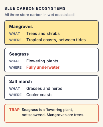
- Blue carbon: carbon stored by coastal ecosystems (mangroves, seagrasses and salt marshes) is called blue carbon. A 2011 study of Indo-Pacific mangroves found they can store up to four times more carbon per hectare than most tropical forests, most of it locked in the waterlogged soil. When mangroves are cut, this carbon is released.
- Biodiversity: mangroves are home to species such as the Royal Bengal tiger (Sundarbans), the saltwater crocodile (Bhitarkanika) and many birds.
- Water quality: they trap sediment and pollutants before these reach the sea and coral reefs.
Where are India's mangroves?
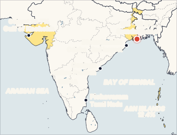
According to the India State of Forest Report (ISFR) 2023, India's mangrove cover is 4,991.68 sq km, about 0.15% of the country's geographical area. The top three are:
- West Bengal: about 42.45% of India's mangroves (mostly the Sundarbans)
- Gujarat: about 23.66% (Gulf of Kachchh and Gulf of Khambhat)
- Andaman and Nicobar Islands: about 12.39%
Important mangrove sites in India
- Sundarbans (West Bengal): part of the largest mangrove forest in the world, shared with Bangladesh (about 66% in Bangladesh, 34% in India), formed by the Ganga, Brahmaputra and Meghna deltas. The only mangrove forest with tigers. Sundarbans National Park became a UNESCO World Heritage Site in 1987; the Sundarban Wetland became a Ramsar site on 30 January 2019. It is also a Biosphere Reserve (declared by India in 1989, part of UNESCO's world network since 2001).
- Bhitarkanika (Odisha): India's second-largest mangrove ecosystem, in the Brahmani-Baitarani delta; a Ramsar site since 19 August 2002; famous for saltwater crocodiles. Nearby Gahirmatha is a major nesting beach of Olive Ridley turtles.
- Pichavaram (Tamil Nadu), Coringa (Andhra Pradesh) and the Gulf of Kachchh (Gujarat) are other well-known mangrove areas.
How are mangroves protected in India?
- Coastal Regulation Zone (CRZ) Notification, 2019 (under the Environment (Protection) Act, 1986): mangroves fall in CRZ-IA, the most protected, ecologically sensitive category. Where a mangrove area is more than 1,000 square metres, a 50-metre buffer zone along the mangroves is also treated as CRZ-IA.
- Forest laws: many mangroves are notified as reserved forests, national parks or sanctuaries under the Indian Forest Act, 1927 and the Wildlife (Protection) Act, 1972.
- MISHTI (Mangrove Initiative for Shoreline Habitats & Tangible Incomes): announced in the Union Budget 2023-24 and launched on 5 June 2023 by the Ministry of Environment, Forest and Climate Change. It aims to restore or plant about 540 sq km of mangroves across nine coastal states and four Union Territories over 2023-2028, using funds from MGNREGS, CAMPA and other sources.
- Mangrove Alliance for Climate (MAC): a global alliance launched at COP27 (Sharm el-Sheikh, Egypt, November 2022); India joined it.
Global picture
The International Day for the Conservation of the Mangrove Ecosystem is observed every year on 26 July; UNESCO declared it in 2015. In May 2024, the IUCN published the first global assessment of mangrove ecosystems under its Red List of Ecosystems. It found that more than half of the world's mangrove ecosystems are at risk of collapse by 2050 (rated Vulnerable, Endangered or Critically Endangered), and nearly 20% are at high risk (Endangered or Critically Endangered). Climate change, especially sea-level rise, is a major threat.
Commonly confused concepts
- Mangrove vs mangal: "Mangrove" is the individual tree or shrub; "mangal" or "mangrove forest" is the whole ecosystem.
- Mangroves vs seagrass vs salt marsh: All three are blue carbon ecosystems. Mangroves are trees (tropical coasts); seagrasses are flowering plants that grow fully underwater; salt marshes are grasses and herbs, common in cooler coasts.
- Mangroves vs coral reefs: Mangroves are plants on the shore line; coral reefs are colonies of tiny animals in clear, shallow sea water. Both protect coasts and are both in CRZ-IA.
- Ramsar site vs World Heritage Site: A Ramsar site is a wetland of international importance under the Ramsar Convention (1971); a World Heritage Site is listed by UNESCO under the World Heritage Convention (1972). The Sundarbans is both. On the Indian side, the two listings have different names: Sundarbans National Park is the World Heritage Site (1987) and the Sundarban Wetland is the Ramsar site (2019).
Issues, criticism and the way forward
- Loss to development: ports, roads, aquaculture (shrimp farms), salt pans and real-estate have cleared mangroves along many coasts.
- Weak buffers on private land: critics argue that some readings of the CRZ 2019 rules weaken protection for mangroves on private land and in inter-tidal areas.
- Planting vs survival: many plantation drives plant the wrong species in the wrong places, and survival rates are low. Experts say restoring natural water flow is often better than mass planting.
- Sea-level rise and less fresh water: dams upstream reduce fresh water and silt reaching deltas such as the Sundarbans, making the water saltier and the land sink.
- Way forward: use mangroves as part of hybrid coastal defences (nature plus engineering), involve local communities as forest guardians, map and protect mangroves on all land types, and link restoration to blue carbon finance.
Concepts to Know
- Brackish water: Water that is a mix of fresh river water and salty sea water.
- Inter-tidal zone: The strip of coast that is under water at high tide and exposed at low tide.
- Storm surge: A sudden rise of sea water pushed onto land by the strong winds of a cyclone.
- Ramsar site: A wetland listed as internationally important under the Ramsar Convention, signed in Ramsar, Iran, in 1971.
- CAMPA: Compensatory Afforestation Fund Management and Planning Authority, which manages money paid by projects that cut forests, to be used for planting and restoring forests.
- India's mangrove cover (ISFR 2023): 4,991.68 sq km, about 0.15% of geographical area
- Top states: West Bengal 42.45%, Gujarat 23.66%, Andaman and Nicobar Islands 12.39%
- Sundarbans: part of the world's largest mangrove forest (shared with Bangladesh); Sundarbans National Park a UNESCO World Heritage Site 1987; Sundarban Wetland a Ramsar site 30 January 2019
- Bhitarkanika: second-largest in India; Ramsar site 19 August 2002; saltwater crocodiles
- CRZ 2019: mangroves in CRZ-IA; where the mangrove area is more than 1,000 sq m, a 50 m buffer along it is also CRZ-IA
- MISHTI: launched 5 June 2023; about 540 sq km; 9 states + 4 UTs; 2023-2028
- Mangrove Alliance for Climate: launched at COP27 (2022); India a member
- IUCN Red List of Ecosystems (May 2024): more than half of mangrove ecosystems at risk of collapse
- International Day for the Conservation of the Mangrove Ecosystem: 26 July (UNESCO, 2015)
● Tracked since March 21, 2026 · last seen November 17, 2026 · updates as the daily brief publishes