Landslides in India
Causes, Hazard Zones and Risk Management
A landslide is the sudden movement of rock, soil or debris down a slope. It happens when the force pulling the slope down (gravity) becomes stronger than the force holding it in place. Heavy rain, earthquakes, and human actions like cutting slopes for roads all upset this balance. In India, landslides kill people every monsoon, mostly in the Himalayas, the North-East and the Western Ghats.
Why does a slope fail?
Think of a pile of sand on a table. A dry pile holds a steep shape. Pour a little water on it and part of it slides away. Soil and rock on a hill behave the same way. Every slope has a "resisting" force: the grip between grains of soil, the strength of rock and the hold of tree roots.
It also has a "driving" force: the weight of the soil and anything on top of it, pulled downhill by gravity. A landslide happens when the driving force wins.
What sets off a landslide?
Experts separate the slow causes from the final trigger.
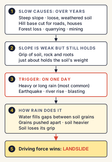
- Causes that make a slope weak over time: steep slopes, loose or weathered soil, cracks in rock, loss of forest cover, quarrying, mining, and cutting the base of hills for roads, houses or plantations.
- Triggers that make it fail on a given day: very heavy or long rain (the most common trigger in India), earthquakes, a sudden rise in river level, and blasting.
- Rain is so important because water fills the gaps between soil grains. This water pushes the grains apart and also makes the soil heavier. The soil loses its grip and starts to move.
What are the main types?
Geologists sort landslides by how the material moves (the widely used Varnes classification).
- Falls: rock or soil drops freely from a cliff, like stones falling on a hill road.
- Topples: a block of rock tips forward and rotates out of the slope.
- Slides: a mass moves along a clear surface. In a rotational slide the surface is curved like a spoon. In a translational slide it moves along a flat surface, such as a rock layer.
- Spreads: a layer spreads sideways, often when soil below turns soft.
- Flows: wet material moves like a thick liquid. Debris flows and mudflows are the deadliest kind in the Western Ghats and Himalayas, because they travel fast and far down valleys.
Where in India are landslides most common?
About 0.42 million sq km, or 12.6% of India's land area (not counting snow-covered areas), is prone to landslides. The main zones are:
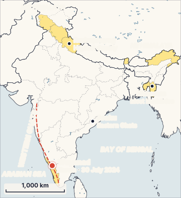
- North-East Himalaya (Mizoram, Tripura, Sikkim, Arunachal Pradesh and others), the largest share.
- North-West Himalaya (Uttarakhand, Himachal Pradesh, Jammu and Kashmir).
- Western Ghats and Konkan hills (Kerala, Karnataka, Goa, Maharashtra, Tamil Nadu's Nilgiris).
- Eastern Ghats, mainly the Araku region of Andhra Pradesh, a much smaller share.
The Himalayas are young mountains. They are still rising, the rocks are broken, and earthquakes are frequent. The Western Ghats are much older and harder. But they get very heavy monsoon rain on steep slopes covered with a thick layer of weathered soil (laterite). When this soil gets soaked, it can slide off the hard rock below.
What does the Landslide Atlas show?
In 2023, ISRO's National Remote Sensing Centre (NRSC) released the Landslide Atlas of India. It mapped about 80,933 landslides recorded between 1998 and 2022 using satellite images.
- Mizoram recorded the most landslides (12,385), followed by Uttarakhand (11,219).
- Rudraprayag and Tehri Garhwal districts in Uttarakhand had the highest landslide density and the highest risk to people and property among 147 districts studied.
- Kerala, especially Thrissur, Palakkad, Malappuram and Idukki, had several high-risk districts outside the Himalayas.
Major disasters to remember
These examples help in Mains answers.
- Kedarnath, Uttarakhand (June 2013): extreme rain, a glacial lake burst and landslides together killed thousands.
- Malin, Pune district, Maharashtra (30 July 2014): a hillside buried almost the entire village.
- Pettimudi, Idukki, Kerala (August 2020): a slide buried the homes of tea estate workers.
- Taliye, Raigad, Maharashtra (July 2021): heavy rain caused a slide that buried a village.
- Shirur, Uttara Kannada, Karnataka (July 2024): a hill cut for a national highway collapsed.
- Wayanad, Kerala (30 July 2024): debris flows swept through Mundakkai and Chooralmala villages, killing more than 200 people. It was one of India's deadliest landslide disasters.
Who manages landslide risk in India?
Several bodies share the work.
- Geological Survey of India (GSI), under the Ministry of Mines, has been the nodal agency for landslide studies since 2004. It maps, studies and forecasts landslides.
- National Disaster Management Authority (NDMA), set up under the Disaster Management Act, 2005, writes policy. It issued Guidelines on Landslides and Snow Avalanches in 2009 and the National Landslide Risk Management Strategy in September 2019.
- National Landslide Susceptibility Mapping (NLSM): GSI has mapped about 4.3 lakh sq km of landslide-prone land at a scale of 1:50,000. Each area is marked as low, moderate or high susceptibility. ("Susceptibility" simply means how likely a place is to have a landslide.)
- National Landslide Forecasting Centre: GSI set it up in Kolkata in 2024. It issues colour-coded district warnings through the Bhusanket web portal and the Bhooskhalan mobile app. It started with 16 districts in six states and covered 21 districts in eight states by 2025. Darjeeling, Kalimpong and the Nilgiris are among them.
- Funding for relief: landslide is one of the centrally notified disasters for which states can use the State Disaster Response Fund (SDRF) and, for severe cases, the National Disaster Response Fund (NDRF).
What does the 2019 strategy say?
It lays out a full chain of steps:
- Hazard mapping at finer scales for towns and roads.
- Monitoring and early warning systems using rain gauges and sensors.
- Awareness and training for local people and officials.
- Rules for building and land use on slopes, including slope-safe road design.
- Special plans for mountain areas and capacity building of state agencies. It was also India's step towards the Sendai Framework for Disaster Risk Reduction (2015-2030), the global plan that asks countries to reduce disaster deaths and losses.
Commonly confused concepts
- Landslide vs avalanche: a landslide moves rock, soil or debris. An avalanche moves snow and ice.
- Landslide vs land subsidence: a landslide moves down a slope. Subsidence is the ground sinking straight down, as seen in Joshimath, Uttarakhand, in early 2023.
- Debris flow vs flash flood: a flash flood is mostly water. A debris flow is mostly mud, rock and trees, so it is far heavier and more destructive.
- Susceptibility vs hazard vs risk: susceptibility is how likely a slope is to fail. Hazard adds when and how big. Risk adds what is in the way: people, houses and roads. A remote unstable slope may have high susceptibility but low risk.
- Landslide Atlas (NRSC, ISRO) vs NLSM maps (GSI): the Atlas is an inventory of landslides seen from satellites. NLSM maps show which areas are likely to slide in future.
Issues, criticism and the way forward
- Unplanned building on slopes: roads, homestays and plantations often cut into the base of hills without slope studies. This removes the slope's support.
- Quarrying and loss of forests: blasting shakes rock, and clearing trees removes roots that bind soil. This is why ESA rules in the Western Ghats target quarrying.
- Heavier rain in short bursts: studies of the Western Ghats show more days of very intense rain. Soaked soil fails faster, so climate change is making landslides more frequent.
- Early warning still limited: forecasts cover only a small number of districts so far. Many villages still get no local alerts.
- Maps not used in planning: susceptibility maps exist, but many town plans and building permits do not use them.
- The way forward: experts suggest using hazard maps in zoning and building rules, expanding district-level warnings, protecting forests and wetlands on slopes, safe road design with drainage, and training local communities to move to safety when warnings come.
Concepts to Know
- Weathering: the slow breaking down of rock into soil by rain, heat and plants. Thick weathered soil on a slope is easier to wash away.
- Laterite: a red, iron-rich soil formed in hot, very rainy places like the Western Ghats. It is strong when dry but weak when soaked.
- Remote sensing: studying the Earth from satellites or aircraft, without going to the place. ISRO uses it to spot landslide scars.
- Sendai Framework: a global plan adopted in 2015 at a UN conference in Sendai, Japan. It sets targets to reduce disaster deaths and losses by 2030.
- Notified disaster: a disaster on the Centre's official list. Relief for it can be paid from the SDRF and NDRF.
- About 0.42 million sq km (12.6% of India's land area, excluding snow-covered areas) is landslide-prone.
- Landslide Atlas of India (NRSC, ISRO, 2023): about 80,933 landslides (1998-2022); Mizoram highest count (12,385); Rudraprayag and Tehri Garhwal highest density and risk.
- GSI: nodal agency for landslide studies since 2004; NLSM has mapped about 4.3 lakh sq km at 1:50,000.
- NDMA: Landslide guidelines 2009; National Landslide Risk Management Strategy, September 2019.
- National Landslide Forecasting Centre, Kolkata (2024): Bhusanket portal, Bhooskhalan app.
- Wayanad (30 July 2024), Malin (2014), Pettimudi (2020), Taliye (2021), Shirur (2024) are major Western Ghats landslides.
● Tracked since November 09, 2026 · last seen November 09, 2026 · updates as the daily brief publishes