Arunachal Frontier Highway
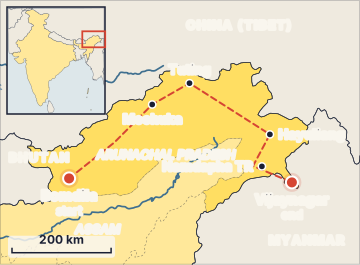
The Arunachal Frontier Highway is a long new highway being built across the northern edge of Arunachal Pradesh, close to India's border with China (Tibet). Its official number is National Highway 913 (NH-913), and it is also called the Bomdila-Vijaynagar Highway. It is about 1,748 km long and runs from the west of the state to the far east. Its aim is to connect remote border valleys, help the armed forces move quickly, and bring development to people living near the border.
Why does it exist?
Arunachal Pradesh is a land of steep mountains and deep river valleys that run north to south. Each valley is like a separate room with no door to the next one. To go from one border valley to another, people and soldiers often had to drive all the way down to the plains of Assam and then climb up again.
That can take days. Meanwhile, China built a large network of roads and railways on its side of the border in Tibet. A highway that runs east-west, along the border, links these "rooms" directly. It allows inter-valley connectivity, faster troop movement, and better access for villages that were cut off for months.
Where did it come from?
- The highway was identified among the border road corridors planned for the North-East.
- In October 2014, the Union Government said it would speed up the project.
- In 2016, the Empowered Committee on Border Infrastructure asked the Ministry of Road Transport and Highways (MoRTH) to prepare detailed project reports (DPRs), based on an alignment agreed by the Home Ministry, the Defence Ministry and the State Government.
- The alignment was improved in 2018 to add more connectivity.
- By late 2022, construction had started on some stretches, and the whole route was notified as NH-913.
- In 2024, MoRTH sanctioned several large packages. For example, in February 2024 it approved about Rs 6,728 crore for eight stretches covering about 305 km, and in March 2024 it approved about Rs 6,621 crore for eight packages covering about 265 km.
How does it work?
The project is planned and funded by the Union Government and built in parts:
- Implementing ministry: MoRTH, with construction carried out through agencies such as the Arunachal Pradesh Public Works Department.
- Funding: fully government-funded, under the EPC (engineering, procurement and construction) model. In EPC, one contractor designs, buys materials and builds the road for a fixed price, and the government pays for it.
- Packages: the route is divided into nine main packages, from Nafra-Lada in the west to Miao-Vijaynagar in the east.
- Road type: mostly intermediate lane (about 5.5 m wide), with some two-lane stretches. About 800 km is greenfield, meaning a completely new road where none existed.
The route and key facts
- Start: near Bomdila, in West Kameng district (with the western link starting near the Tawang area).
- End: Vijaynagar, in Changlang district, near the India-Myanmar border.
- Districts it passes through: West Kameng, East Kameng, Kurung Kumey, Upper Subansiri, West Siang, Upper Siang, Dibang Valley, Lower Dibang Valley, Anjaw and Changlang.
- Key places on the way: Nafra, Sarli, Huri, Mechuka, Tuting, Hunli, Hayuliang, Hawai and Miao.
- Distance from the border: it runs close to the McMahon Line, in some places about 20 km from the LAC.
- Cost: about Rs 27,000 crore for the highway itself, and about Rs 40,000 crore including six inter-corridor highways [figures vary across sources].
- Completion target: revised to FY 2028-29 (by 31 March 2029), with sections opening from 2027.
The three east-west highways of Arunachal
It helps to picture three long horizontal lines across the state, from top to bottom:
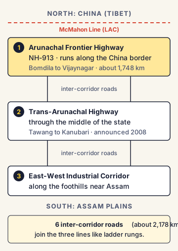
- Arunachal Frontier Highway (NH-913): the top line, along the China border.
- Trans-Arunachal Highway: the middle line, through the centre of the state, from Tawang to Kanubari. It was announced in 2008.
- East-West Industrial Corridor: the bottom line, along the foothills near the Assam border.
Six inter-corridor roads, about 2,178 km in total, are planned to join these three lines like the rungs of a ladder.
India's position and wider links
The Frontier Highway is part of India's larger push to build infrastructure near the LAC. It works together with:
- BRO roads and tunnels, such as the Sela Tunnel to Tawang.
- The Vibrant Villages Programme, under which feeder roads to about 122 border villages (about Rs 2,205 crore) are to connect to the highway.
- India's Act East Policy, which aims to improve connectivity in the North-East and with South-East Asia.
Commonly confused concepts
- Frontier Highway vs Trans-Arunachal Highway: The Frontier Highway runs along the northern border with China. The Trans-Arunachal Highway runs through the middle of the state and is older.
- MoRTH vs BRO: The Frontier Highway is a MoRTH national highway project. BRO, under the Ministry of Defence, builds many other strategic roads and tunnels near the border. Both contribute to border connectivity.
- Greenfield vs brownfield: A greenfield road is built on new land where no road existed. A brownfield project upgrades or widens an existing road.
- McMahon Line vs LAC: The McMahon Line was drawn at the Simla Conference of 1913-14, and India treats it as the boundary in the east. The LAC is the line of actual control on the ground, which in the east broadly follows the McMahon Line.
Issues, criticism and the way forward
- Difficult terrain: Steep slopes, heavy rain, landslides and earthquakes make construction slow and costly, and roads need constant repair.
- Environment and wildlife: In July 2025, the Standing Committee of the National Board for Wildlife (NBWL) cleared the diversion of about 310 hectares of land in Namdapha Tiger Reserve (Changlang district) for a stretch of the highway. This involves felling over 1.5 lakh trees. Some experts and committee members raised concerns about the loss of forest and the safety of animals such as tigers, clouded leopards and red pandas.
- Delays: Approvals for land, forest and wildlife clearances have taken time, so the completion target has moved from 2027 to 2029.
- Local communities: Land acquisition in tribal areas needs consent and fair compensation, in line with local customs and laws.
- Security concerns: Analysts note that as both India and China build roads closer to the LAC, troops can be moved faster on both sides. This can raise the risk that small incidents grow quickly.
- Way forward: Experts suggest using wildlife underpasses and careful slope engineering, finishing clearances faster, involving local communities, and linking the highway with the Vibrant Villages Programme so it brings jobs and tourism, not only military access.
Concepts to Know
- Inter-valley connectivity: Roads that connect one river valley directly to the next, instead of forcing travel down to the plains and back up.
- Intermediate lane road: A road wider than a single lane but narrower than a full two-lane road, about 5.5 metres wide. It suits mountain areas where space is limited.
- Detailed Project Report (DPR): A detailed plan for a project, with its route, design, cost and timeline, prepared before construction is approved.
- EPC model: A contract where one company handles engineering (design), procurement (buying materials) and construction, and the government pays the full cost.
- Diversion of forest land: Official permission to use forest land for a non-forest purpose, such as a road. It needs clearance under forest and wildlife laws.
- Act East Policy: India's policy, launched in 2014, to deepen ties with South-East and East Asia, with the North-East as the gateway.
- Official name: National Highway 913 (NH-913), also called the Bomdila-Vijaynagar Highway
- Length: about 1,748 km, including about 800 km of new (greenfield) road
- Route: from near Bomdila (West Kameng) to Vijaynagar (Changlang), through 10 districts, along the McMahon Line
- Built by MoRTH in 9 main packages; fully government-funded on the EPC model
- Cost: about Rs 27,000 crore for the highway; about Rs 40,000 crore with six inter-corridors
- 2016: Empowered Committee on Border Infrastructure asked MoRTH to prepare DPRs
- Completion target: FY 2028-29
- NBWL Standing Committee (July 2025): about 310 hectares of Namdapha Tiger Reserve diverted for the highway
- Six inter-corridors (about 2,178 km) link it with the Trans-Arunachal Highway and the East-West Industrial Corridor
● Tracked since November 15, 2026 · last seen November 15, 2026 · updates as the daily brief publishes