Amazon Rainforest
Geography, Ecology and Deforestation
The Amazon rainforest is the largest tropical rainforest on Earth. It covers about 5.5 million sq km in the northern part of South America, inside a river basin of about 7 million sq km. It is spread across nine countries, and Brazil holds the biggest share, close to 60%. It is home to a huge variety of plants and animals, and it plays a big role in the world's climate and water cycle.
Where exactly is it?
Picture the top half of South America. The Andes mountains stand on the west. The Atlantic Ocean lies on the east. Between them is a vast, low, flat basin drained by the Amazon River and its many tributaries (smaller rivers that join a bigger one). The rainforest fills most of this basin.
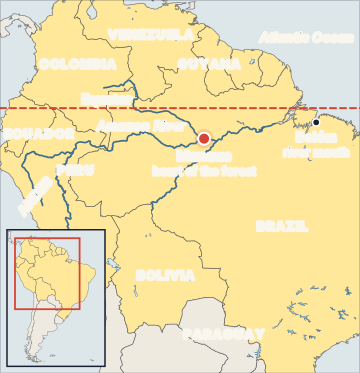
The nine countries that share the forest are:
- Brazil (the largest share, about 58–64% depending on the source)
- Peru (the second largest share, about 13%)
- Bolivia, Colombia, Venezuela, Ecuador
- Guyana, Suriname
- French Guiana (an overseas region of France, not an independent country)
What is its climate like?
The Amazon lies on and near the Equator. It has an equatorial or tropical rainforest climate (Köppen type Af). It is hot all year, around 25–30°C, with no real cold season. It rains a lot, usually 2,000–3,000 mm a year, and there is no long dry season. The air is very humid. This steady heat and rain is why trees can grow tall and dense all year round.
What makes the forest so rich?
The forest has layers, like floors of a building:
- Emergent layer: a few giant trees that rise above everything else.
- Canopy: a thick roof of leaves and branches, where most life is found.
- Understorey: smaller trees and shrubs in low light.
- Forest floor: dark and damp, covered with fallen leaves that rot quickly.
Scientists estimate the Amazon has about 390 billion trees of around 16,000 species. It is the most biodiverse tropical forest tract in the world. A surprising fact: the soil is usually poor. Heavy rain washes nutrients away (this is called leaching). Most nutrients are stored in the living plants and are recycled quickly from rotting leaves. So when the forest is cleared, the land often becomes poor for farming within a few years.
The Amazon River
The Amazon River starts in the Andes in Peru and flows east across Brazil into the Atlantic Ocean. It is the largest river in the world by the volume of water it carries (its discharge). It alone carries about 15–18% of all the river water that flows into the world's oceans. (The Nile is usually called the longest river; the Amazon is the largest by water flow.)
Why does the world care about it?
The Amazon matters far beyond South America:
- Carbon store: Its trees and soil hold an estimated 150–200 billion tonnes of carbon. If this carbon is released by burning or cutting, it adds carbon dioxide to the air and speeds up global warming.
- Flying rivers: The trees pull water from the soil and release it as vapour through their leaves (this is called transpiration). This moist air moves across the continent like a river in the sky. Scientists call these "flying rivers". They bring rain to farms and cities far away, including southern Brazil and neighbouring countries.
- Biodiversity: It holds a large share of the world's known species, many found nowhere else.
- People: Hundreds of Indigenous groups live in the Amazon, and their territories are among the best-protected forest areas.
What is deforestation and what drives it?
Deforestation means clearing a forest fully and turning the land into something else, like pasture or farmland. In the Amazon, the main drivers are:
- Cattle ranching: the biggest single driver. Forest is cut and burned to make grassland for cows.
- Soy and other crops: large farms spread into cleared areas.
- Illegal logging and mining: especially illegal gold mining in rivers and Indigenous lands.
- Roads and settlements: big highways built from the 1970s opened the forest to settlers and land grabbers.
- Land grabbing: people clear public forest to claim it as private land.
How does Brazil measure forest loss?
Brazil's space agency, INPE (National Institute for Space Research), runs two satellite systems:
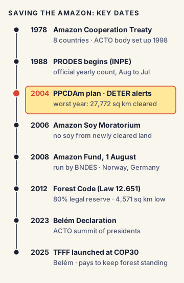
- PRODES: the official yearly count of clear-cut forest. It has run since 1988. Its "year" runs from August to July, because the rainy season makes cloud-free images hard to get at other times. This is the number used for national targets.
- DETER: a near-real-time alert system that has run since 2004. It sends quick warnings of fresh clearing to enforcement teams, so officers can act fast.
Simply put, PRODES is like the final yearly exam result, and DETER is like the daily attendance register that alerts the teacher early.
How has the deforestation rate changed?
The story has big ups and downs:
- 2004: one of the worst years, about 27,772 sq km cleared.
- 2004 onwards: Brazil launched PPCDAm, a national plan with more protected areas, satellite monitoring and strict enforcement. A soy industry agreement (the Amazon Soy Moratorium, 2006) also stopped companies from buying soy grown on newly cleared land.
- 2012: the rate fell to about 4,571 sq km, which stayed the record low for many years.
- 2019–2022: enforcement weakened and more than 45,000 sq km was cleared.
- From 2023: PPCDAm was revived and the rate began to fall again, reaching a new record low of 3,335 sq km for August 2025 to July 2026.
What are Brazil's main protection tools?
- Legal Amazon: a planning region of about 5 million sq km (about 59% of Brazil) covering nine Brazilian states: Acre, Amapá, Amazonas, Mato Grosso, Pará, Rondônia, Roraima, Tocantins and part of Maranhão. Many forest laws and plans apply to this region.
- Forest Code (Law 12.651 of 2012): It requires private landowners in Amazon forest areas to keep 80% of their land as a "legal reserve" of native vegetation. In most other parts of Brazil the figure is 20%.
- Amazon Fund (2008): set up by a decree on 1 August 2008 and managed by Brazil's development bank, BNDES. It collects donations (mainly from Norway and Germany) and spends them as grants on stopping deforestation. Donors pay in when Brazil shows lower forest loss.
- Protected areas and Indigenous lands: large parts of the forest are legally protected.
Regional and global cooperation
- Amazon Cooperation Treaty (1978): signed by eight Amazon countries to protect and develop the region together. In 1998 they created the Amazon Cooperation Treaty Organization (ACTO), with a permanent secretariat in Brasília since 2003. Its eight members are Bolivia, Brazil, Colombia, Ecuador, Guyana, Peru, Suriname and Venezuela. France (French Guiana) is not a member.
- Belém Declaration (August 2023): adopted at an ACTO summit of presidents in Belém, Brazil, to coordinate action against deforestation.
- Tropical Forest Forever Facility (TFFF): launched by Brazil at COP30 in Belém in November 2025. It is a large investment fund that aims to pay tropical-forest countries every year for each hectare of forest they keep standing. It aims to grow to about US$125 billion, and at least 20% of its payments are reserved for Indigenous peoples and local communities.
What is the "tipping point"?
Scientists warn the Amazon could reach a point of no return. If too much forest is lost, there are fewer trees to recycle rain. The forest then gets drier, fires spread more easily, and large parts could slowly turn into dry, grassy savanna. Scientists Thomas Lovejoy and Carlos Nobre estimated in 2018 that this could happen when 20–25% of the forest is lost. About 17% of the whole Amazon basin had already been cleared by then, and close to 20% in the Brazilian Amazon.
Commonly confused concepts
- Amazon rainforest vs Amazon basin vs Legal Amazon: The basin (about 7 million sq km) is all the land drained by the Amazon River. The rainforest (about 5.5 million sq km) is the forest inside it, across nine countries. The Legal Amazon (about 5 million sq km) is a planning region inside Brazil only, and it also includes some non-forest land.
- PRODES vs DETER: PRODES gives the official yearly total (since 1988). DETER gives quick daily alerts for enforcement (since 2004).
- Deforestation vs degradation: Deforestation is full clearing. Degradation means the forest still stands but is damaged by fire, selective logging or drought. Degradation can be as large as clearing, and PRODES clear-cut figures do not fully capture it.
- ACTO vs Amazon Fund vs TFFF: ACTO is an organisation of eight governments. The Amazon Fund is a Brazilian grant fund run by BNDES. The TFFF is a global investment fund for all tropical forests, not just the Amazon.
- "Lungs of the world": This popular phrase is misleading. The forest makes a lot of oxygen, but its own plants, animals and microbes use up almost all of it. Its real global value is as a carbon store, a rain-maker and a biodiversity home.
- Amazon vs other great rainforests: The Congo Basin forest in Central Africa is the second largest. South-East Asian rainforests (Borneo, Sumatra, New Guinea) come next. In India, the tropical wet evergreen forests of the Western Ghats and the North-East are similar in type but much smaller.
Issues, criticism and the way forward
- Degradation is rising: Fire, logging and drought now damage forest faster than clear-cutting in some years. Experts say targets should count degradation, not just clearing.
- Climate stress: Droughts linked to El Niño and global warming dry out the forest and make fires spread, even when clearing falls.
- Policy swings: Deforestation has risen and fallen sharply with changes in enforcement. Experts argue that strong laws, steady funding and monitoring must continue whichever government is in power.
- Economic pressure: Cattle, soy and mining bring income. Supporters of a "forest economy" say that paying people to keep forests standing (through funds like the Amazon Fund and TFFF) and supporting sustainable products like açaí and Brazil nuts can make protection pay.
- Rights of Indigenous people: Indigenous lands have some of the lowest deforestation. Experts recommend legally recognising more such lands and protecting them from illegal miners and land grabbers.
- Supply chains: Importing countries are adding rules so that goods like beef and soy are not linked to cleared forest. Critics in producer countries say such rules can act as trade barriers.
Concepts to Know
- Tributary: A smaller river that flows into a bigger river.
- Transpiration: The process in which plants pull water from the soil and release it into the air as vapour through tiny holes in their leaves.
- Leaching: When heavy rain washes nutrients down and out of the soil, leaving the top soil poor.
- Biodiversity: The variety of living things (plants, animals, microbes) in a place.
- Carbon store (carbon stock): The amount of carbon held in trees, plants and soil. When forests burn or rot, this carbon goes into the air as carbon dioxide, a greenhouse gas that traps heat.
- Savanna: A grassland with scattered trees and a long dry season, like parts of central Brazil or East Africa.
- El Niño: A natural warming of the Pacific Ocean every few years that changes weather worldwide. In the Amazon it often brings drought.
- Köppen classification: A system that groups the world's climates by temperature and rainfall. "Af" means hot and wet all year.
- COP30: The 30th Conference of the Parties, the yearly UN climate summit, held in Belém, Brazil, in November 2025.
- Rainforest area: about 5.5 million sq km; basin: about 7 million sq km
- Shared by 9 countries; Brazil holds the largest share (about 60%), then Peru (about 13%)
- Climate: Köppen Af; rainfall about 2,000–3,000 mm a year
- About 390 billion trees, about 16,000 tree species; stores about 150–200 billion tonnes of carbon
- Amazon River: largest in the world by discharge, about 15–18% of global river flow into oceans
- PRODES (INPE): official yearly count since 1988, year runs August to July; DETER: real-time alerts since 2004
- Peak loss around 2004: about 27,772 sq km; 2012 low: about 4,571 sq km
- PPCDAm launched 2004; Amazon Soy Moratorium 2006; Amazon Fund 1 August 2008 (BNDES)
- Forest Code (Law 12.651/2012): 80% legal reserve in Amazon forest areas
- Legal Amazon: about 5 million sq km, about 59% of Brazil, nine states
- Amazon Cooperation Treaty 1978; ACTO created 1998; secretariat in Brasília; 8 members (French Guiana not a member)
- Belém Declaration: August 2023; TFFF launched at COP30, Belém, November 2025 (target about US$125 billion)
- Tipping point estimate: 20–25% forest loss (Lovejoy and Nobre, 2018)
● Tracked since October 17, 2026 · last seen October 17, 2026 · updates as the daily brief publishes